


Verneuil sur Avre 20.28

togolo28
User
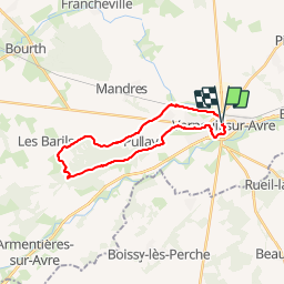

Length
20 km

Max alt
209 m

Uphill gradient
143 m
Km-Effort
22 km

Min alt
162 m

Downhill gradient
142 m
Boucle
Yes
Creation date :
2019-01-24 23:54:52.502
Updated on :
2019-03-22 19:30:32.176
--
Difficulty : Medium

FREE GPS app for hiking
 SityTrail
IGN / Geographical institutes
SityTrail Plus
The world is yours!
About
Trail On foot of 20 km to be discovered at Normandy, Eure, Verneuil d'Avre et d'Iton. This trail is proposed by togolo28.
Description
Attention! Pour les amoureux des sentiers, la voie verte des Bois Francs est bitumée!
Positioning
Country:
France
Region :
Normandy
Department/Province :
Eure
Municipality :
Verneuil d'Avre et d'Iton
Location:
Verneuil-sur-Avre
Start:(Dec)
Start:(UTM)
347683 ; 5400565 (31U) N.
Comments